
Sentieristica
La Sentieristica del Parco Nazionale del Vesuvio è costituita da 11 sentieri per una lunghezza complessiva di 54 Km di camminamento. Sono state realizzate diverse tipologie di sentieri: sei sentieri natura circolari (n. 1, 2, 3, 4, 5 e 8), un sentiero educativo (n.9), un sentiero panoramico (n.6) e un sentiero agricolo (n.7).
- La Valle dell’Inferno: i luoghi più belli e gli ambienti più rappresentativi dell’area protetta;
- Lungo i Cognoli: gli scenari del Somma-Vesuvio più suggestivi e selvaggi;
- Monte Somma: affascinante itinerario ad anello che conduce sino a Punta Nasone, la vetta più alta del Monte;
- Attraverso la Riserva Tirone: il Tracciato si sviluppa all’interno della Riserva Forestale Tirone-Alto Vesuvio;
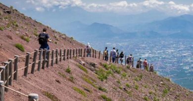
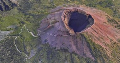
- Il Gran Cono: risalire il sentiero del Gran Cono rappresenta un’esperienza unica;
- La strada Matrone: il sentiero ripercorre l’antica strada tracciata dai fratelli Matrone per risalire al Gran Cono;
- Il Vallone della Profica: l’itinerario si snoda alle pendici del versante meno conosciuto del Monte Somma;
- Il trenino a cremagliera: l’itinerario ricalca il percorso storico per l’ascesa al Vesuvio dalla cittadina di San Sebastiano;
- Il fiume di lava: l’emozione di passeggiare su una colata lavica, attorniati da un paesaggio quasi lunare;
- L’Olivella: l’itinerario ripercorre lo stradello dell’Olivella, tra le campagne di Sant’Anastasia;
- La pineta di Terzigno: il sentiero è strutturato in un percorso pianeggiante, all’interno di una fitta pineta.
Per approfondire: https://www.parconazionaledelvesuvio.it/visita-il-parco/i-sentieri-del-vesuvio/.